
September 19, 2014 — Kīlauea
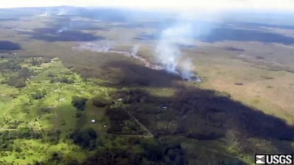
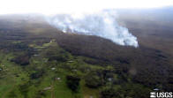
June 27th lava flow continues moving northeast, reaches open ground

The June 27th flow remains active and
heading northeast, moving through Kaohe Homesteads. For
several weeks the flow has been moving through thick forest,
and today the flow front reached the forest boundary and
more open ground. Nevertheless, active portions of the flow
remain in the forest and fires continue. The flow front
today was 2.4 km (1.5 miles) upslope of Apaʻa St.


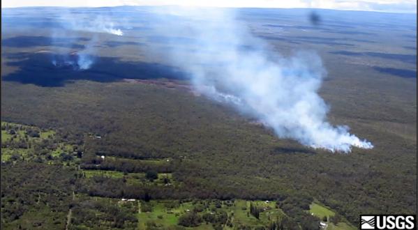
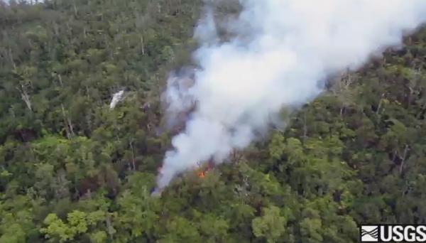
Left: Another view of the narrow
flow front. Kaohe Homesteads is in the lower left portion of
the image. The vent for the June 27th lava flow is on Puʻu ʻŌʻō,
which can be seen on the skyline. Right: View of the
flow front, looking north. Pāhoa is located in the upper
right portion of the photograph. The flow front today was
3.4 km (2.1 miles) from Pāhoa Village Road.

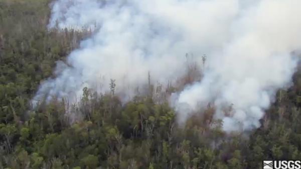
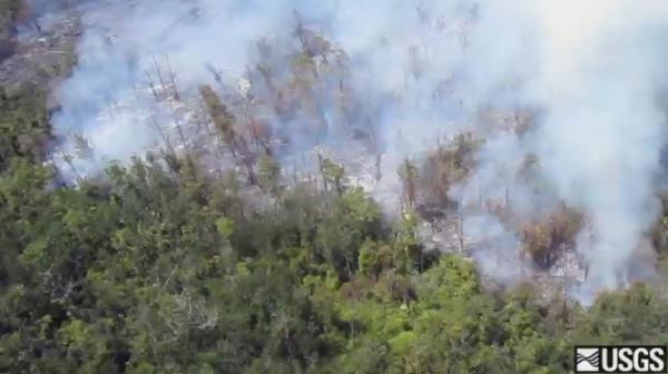
Views of the flow front from two
different angles, with equivalent thermal images for
comparison. The thermal images show that surface breakouts
were focused on three areas near the flow front: 1) the flow
front itself, 2) an area 300 meters (yards) behind the flow
front and 3) a larger area about 1 km (0.6 miles) behind the
flow front.

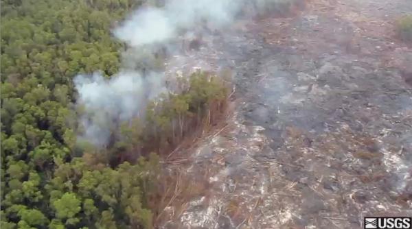
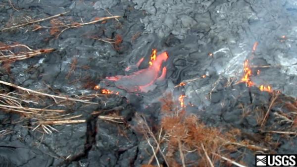
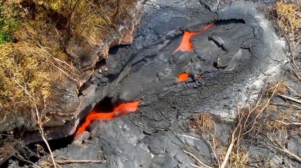
Left: A close-up view of the
surface of the June 27th lava flow, near the flow front. The
pāhoehoe flow is too thin and slow to topple trees as it
passes, but instead the lava surrounds the trees and burns
through the base. When the trees fall over, the flow surface
may have cooled enough that the trunks remain intact. If the
surface is hot enough to burn through the fallen trunks, all
that remains is a line of ashen residue (see right side of
image). Right: This Quicktime movie gives a quick
aerial overview of the activity at the front of the June
27th lava flow. Kaohe Homesteads is in the lower left.
September 17, 2014 — Kīlauea
June 27th lava flow continues advancing northeast in Kaohe Homesteads

The June 27th lava flow remains active
and continues advancing northeast in the forested, northwest
portion of Kaohe Homesteads. The flow front today was 2.7 km
(1.7 miles) from Apaʻa st. and 3.8 km (2.3 miles) from Pāhoa
Village Road. Over past two days, the flow front has
advanced at an average rate of 290 m/day (960 ft/day).


Left: Another view of the flow
front in the northwest portion of Kaohe Homesteads. The
leading portion of the flow front narrowed over the past two
days and was roughly 150 m (500 ft) wide. Right: A
view looking down the axis of the flow at the flow front.
Pāhoa is in the upper right portion of the photograph.


Left: A close-up view of the flow
surface near the flow front, which consisted of numerous,
scattered small pāhoehoe lobes. Right: A view of the
leading tip of the flow, which was moving through thick
forest.
This Quicktime movie provides a brief
aerial overview of activity at the flow front. Kaohe
Homesteads is in the lower left.


Left: This thermal image shows the
scattered pāhoehoe lobes that are active near the front of
the June 27th flow. Right: A view of the flow front
from tree level, with the lava hidden behind numerous tall
trees.
Lava lake activity continues at Kīlauea's summit


Left: The summit eruption
continues, with an active lava lake within Halemaʻumaʻu
Crater. Halemaʻumaʻu fills up most of the image, and the
lava lake can be seen near the bottom of the image contained
within the smaller Overlook crater. Right: A closer
look at the lava lake at Kīlauea's summit. The lake was
roughly 53 m (170 ft) below the floor of Halemaʻumaʻu Crater
this morning.
September 15, 2014 — Kīlauea
June 27th flow enters northwest portion of Kaohe Homesteads

The June 27th lava flow remains active
and continues advancing towards the northeast. Recently, the
flow front entered the Kaohe Homesteads subdivision, and is
currently within the vacant, forested northwest portion of
the subdivision. The flow front was 3.3 km (2.1 miles)
upslope from Apaʻa Road and 4.3 km (2.7 miles) from Pāhoa
Village Road.


Left: Another view of the flow
front, in the northwest portion of Kaohe Homesteads
subdivision. Right: A closer view of surface activity
on the June 27th lava flow. This pāhoehoe flow consists of
many small, scattered, slow-moving lobes burning vegetation.


Left: HVO geologists conduct a VLF
(very-low frequency) survey to measure the rate of lava
flowing through the lava tube on the June 27th lava flow.
Right: An HVO geologist conducts a very-low frequency (VLF)
survey of the lava tube to measure the rate of lava flowing
through the tube. The measurement consists of two steps.
First, a transect of VLF measurements across the roof of the
tube is used to measure the cross-sectional area of lava
flowing through the tube. Second, a radar gun is used to
measure the speed that lava is flowing at that location. An
open skylight is required for this speed measurement. By
multiplying the cross-sectional area with the velocity, the
volume rate of lava flowing through the tube can be
estimated. Today's measurement showed a flow rate of 5.8
cubic meters per second (roughly 1500 gallons per second).
Tracking the lava supply rate like this can be helpful for
anticipating fluctuations in activity at the flow front.
This Quicktime movie provides an aerial
view of activity near the front of the June 27th flow, where
numerous pāhoehoe lobes are slowly burning vegetation.
This Quicktime movie shows the view
through a skylight on the lava tube, which provided a clear
view of the flowing lava stream.
September 12, 2014 — Kīlauea
June 27 flow moving to the northeast

As of Friday afternoon, September 12,
2014, the most distal front of the June 27th lava flow had
reached a straight-line distance of 14.9 km (9.3 miles) from
the source vent on the northeast flank of the Puʻu ʻŌʻō
cone. The flow has continued in the northeast direction that
it assumed in the middle of the week and is now only 171
meters (0.1 miles) from the boundary of the Kaohe Homesteads
community. The flow is still within thick forest, so that
dense plumes of smoke are created as vegetation is consumed.
Small breakouts (visible as plumes in the middle distance)
are also active closer to Puʻu ʻŌʻō, roughly midway along
the length of the June 27th flow.


Left: View looking northeast along
the terminus of the July 27th flow. Kaohe Homesteads is to
the right, and Pāhoa town is in the middle center. The
active flow is in the middle left. Right: View from
above the middle part of the June 27th flow looking south at
a small breakout that is burning forest along the previously
existing flow margin. Heiheiahulu cone is in the upper left.
This Quicktime movie provides an aerial
view of the flow front and its position relative to Kaohe
Homesteads.

The photo on the left is compared here to
a thermal image on the right, which provides a clear view of
the flow front of the June 27th flow through the thick
smoke. The vent for the June 27th flow is on Puʻu ʻŌʻō,
which can be seen at the top of the normal photograph. After
pouring in and out of ground cracks in late August, the flow
finally emerged from the cracks around September 3 and began
spilling out towards the north. The northwest portion of
Kaohe Homesteads subdivision can be seen in the lower left
of the images.
September 10, 2014 — Kīlauea
June 27th flow moves closer to Kaohe Homesteads

The June 27th lava flow remained active
Wednesday afternoon, September 10, 2014, with the most
distal flow front 14.5 km (9.0 mi; straight-line distance)
from the vent on the northeast flank of the Puʻu ʻŌʻō cone,
which is visible in the far background. Over the past day,
the flow front direction shifted from a north trend to a
more northeast trend, bringing the flow closer to the Forest
Reserve boundary. The flow continued to advance through
thick forest, creating smoke plumes as it engulfed trees and
other vegetation. The smell of smoke has been detected far
downwind of the flow, but fires are not spreading beyond the
margin of the flow. Small, sluggish breakouts of lava (smoke
plumes in far distance) also remain active closer to Puʻu
ʻŌʻō, roughly midway along the length of the June 27th flow.


Left: View from above the end of
the June 27th lava flow, looking along its northeast trend
through the Wao Kele o Puna Forest Reserve. On the afternoon
of September 10, 2014, the flow front was 0.6 km (0.4 mi)
from the boundary between the Forest Reserve and Kaohe
Homesteads, visible at far right. Right: Smoke plumes
indicate the location of the June 27th lava flow, which was
0.6 km (0.4 mi) from the edge of Kaohe Homesteads, visible
in foreground, on September 10. The flow was advancing
toward the northeast.
This Quicktime movie provides an overview
of activity near the front of the June 27th lava flow, and
shows the position of the flow front relative to Kaohe
Homesteads and Pahoa.
September 8, 2014 — Kīlauea
June 27th flow continues to advance north


Left: The June 27th flow continues
its advance toward the north, creating a dense smoke plume
as it spreads through the forest. The tip of the active flow
today was 13.7 km (8.5 miles) straight-line distance from
the vent, and 1.2 km (0.7 miles) from the eastern boundary
of the Wao Kele o Puna Forest Reserve. This boundary is the
western edge of Kaohe Homesteads subdivision, seen in the
foreground. Puʻu ʻŌʻō is visible on the horizon, partly
obscured by the smoke plume. The actual length of the flow,
measured along its axis, is 15.7 km (9.8 miles). Right:
This view shows the active flow front from behind. The lava
feeding the flow emerges from a crack parallel to the road
at lower right, which goes to the True/Mid-Pacific
geothermal well site. Kaohe Homesteads is to the right,
Pāhoa is at the upper right, and Ainaloa and Hawaiian
Paradise Park are at upper left.
This Quicktime video provides an aerial
view of the activity at the front of the June 27th lava
flow.
Breakouts remain active closer to Puʻu ʻŌʻō

Several small breakouts persist along the
middle part of the June 27th flow, closer to Puʻu ʻŌʻō. Most
of these breakouts are burning trees as well, as seen in
this photo. The flow front is in the distance, at upper
left, and the closer smoke plumes are from these other
breakouts.
September 6, 2014 — Kīlauea
June 27th flow remains active, with flow front moving north from ground crack

Following a reduction in surface activity
yesterday, we observed an increase in surface flows today
issuing from the ground crack. The reduction yesterday was
likely due to lava filling the deep ground cracks. The flow
front today was moving towards the north from the ground
crack, through thick forest, creating a dense plume of
smoke. The farthest active flows today were 13.2 km (8.2
miles) from the vent on Puʻu ʻŌʻō, and 1.4 km (0.9 miles)
from the eastern boundary of the Wao Kele o Puna forest
reserve. This boundary is the western edge of Kaohe
Homesteads subdivision, seen at the bottom of this
photograph. Puʻu ʻŌʻō is visible on the horizon in the upper
right portion of the photograph.

Another view of the flow front, looking
west. Lava issued from several spots along a deep ground
crack earlier this week, as shown by the distinct fingers of
lava making up the flow front. The thick smoke plumes show
the flow front this morning was moving downslope towards the
north (right in image), but it is too soon to know if this
northerly flow direction will be sustained. Puʻu ʻŌʻō is in
the upper left portion of the photograph.
This Quicktime movie gives a quick aerial
overview of activity at the flow front.

This thermal image looks west at the June
27th flow front. The active tip of the flow is at the right
side of the image, moving north. Lava issued from several
spots along a deep ground crack, which has been traced with
the dotted line in the left portion of the image. In
addition, lava was filling another crack, also marked,
closer to the active tip of the flow.


Left: Lava was filling another
ground crack near the flow front, as indicated by a line of
steam that extended a short distance west of the flow tip.
At two spots along this ground crack we observed small pads
of lava near the surface. Right: A wide view of
Kīlauea and Mauna Loa volcanoes, looking northwest. Puʻu
ʻŌʻō Crater, on Kīlauea's East Rift Zone, is the large
fuming crater just to the left of the image center. Just to
the right of the center point, on the northeast flank of
Puʻu ʻŌʻō cone, smaller fume sources trace the lava tube
supplying lava to the June 27th lava flow (the front of this
flow is out of view to the right). In the distance, a faint
plume of volcanic gas from the summit of Kīlauea can be seen
below the clouds. The broad slopes of Mauna Loa form the
skyline.

Breakouts remain scattered along the June
27th lava flow, and are not just limited to the flow front.
Here surface flows have recently cut a swath through thick
forest.
September 3, 2014 — Kīlauea
June 27th lava flow front emerges again from ground crack, continues advancing eastward

The June 27th lava flow remains active,
with lava at the flow front issuing from a ground crack and
advancing through thick forest, creating dense plumes of
smoke. The farthest lava this afternoon was 13.2 km (8.2
miles) from the vent on Puʻu ʻŌʻō, and 1.3 km (0.8 miles)
from the eastern boundary of the Wao Kele o Puna forest
reserve. This forest reserve boundary is at the western
boundary of Kaohe Homesteads subdivision, a portion of which
is visible at the bottom of the photograph.


Left: This view looks east at the
far end of the June 27th lava flow. In the center of the
photograph is an isolated pad of lava which came out of
ground crack last week. Further movement of lava within
ground cracks has enabled the flow front to advance farther
east, with lava issuing from a ground crack in the upper
left portion of the photograph, where plumes of smoke mark
the location of lava burning forest. Right: A closer
view of the flow front, looking west. It is difficult to see
the active lava surface through the thick smoke. Puʻu ʻŌʻō
can be seen in the upper left portion of the photograph,
partly obscured by smoke.

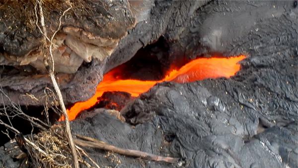
One small portion of the flow front was
quite vigorous, with an open stream of lava moving through
the forest.
This Quicktime movie shows activity at
the front of the June 27th lava flow. The flow front
continues to advance eastward, with lava issuing out of a
ground crack and spreading through dense forest, creating
thick plumes of smoke. The farthest lava this afternoon was
1.3 km (0.8 miles) from the eastern boundary of the Wao Kele
o Puna forest reserve.

The surface flows at the front of the
June 27th lava flow are fed by lava that is supplied through
a lava tube that originates at the vent on Puʻu ʻŌʻō. This
thermal image shows the lava tube close to Puʻu ʻŌʻō.
Although the lava is several meters (yards) beneath the
surface, it heats the surface sufficiently to be easily
detected with thermal cameras.
September 1, 2014 — Kīlauea
June 27th lava flow continues advancing eastward, with lava plunging into another ground crack

This wide view, looking west, shows the
position of the June 27th flow front relative to the nearby
Kaohe Homesteads subdivision. The front of the flow is
moving through thick forest, and its position can be seen by
the plumes of smoke above the center of the photograph. Near
these active surface flows, there was also steaming from a
ground crack, resulting from lava deep in the crack. The
farthest point of this steaming was 1.7 km (1.1 miles) west
of the boundary of the Kaohe Homesteads subdivision.
The June 27th lava flow remains active at
its leading edge, where lava is spreading out slowly into
thick forest and also plunging into one of the many deep
ground cracks that form Kīlauea's East Rift Zone. This
Quicktime video shows the activity near the eastern edge of
the flow. This swiftly moving stream of lava was about 2
meters (yards) wide, and was visible down to about 30 meters
(100 feet) depth in the crack, where it disappeared from
view.
The Quicktime video begins with a view of
the steaming ground crack, where lava is moving deep within
the crack. As the view rotates west, lava can be seen on the
surface burning thick forest. Finally, the camera focuses on
the eastern edge of the flow, where lava is plunging into
the deep ground crack. This swiftly moving stream of lava
was about 2 meters (yards) wide, and was visible down to
about 30 meters (100 feet) depth in the crack, where it
disappeared from view.


Left: Surface flows at the front
of the June 27th flow continue slowly moving through thick
forest, creating scattered brush fires. This view looks
south, and the cone of Heiheiahulu is in the upper left.
Right: Extending slightly beyond the lava flows on the
surface, a steaming ground crack indicates that lava is
continuing to move beneath the surface. The front of the
surface flows is just above and to the right of the center
point of the photograph, and the steaming ground crack runs
along the vertical center line of the photograph. Puʻu ʻŌʻō
can be seen on the horizon in the upper left.


Left: Near the leading edge of the
lava on the surface, there was a swiftly moving stream of
lava pouring into a deep ground crack (see Quicktime videos
above). Puʻu ʻŌʻō is at the top of the photograph. Right:
A closer look at the stream of lava pouring into the deep
ground crack. See Quicktime videos above.
August 29, 2014 — Kīlauea
Far end of June 27th lava flow reactivates, lava spills out of steaming crack

The steaming ground crack observed
yesterday suggested that lava was close to the surface
within the crack, and today lava in the crack reached the
surface and began spilling out into the thick forest. The
leading edge of the lava today was near the abandoned well
site (cleared area at left). This farthest lava was about
11.9 km (7.4 miles) from the vent on Puʻu ʻŌʻō (visible on
horizon) and 2.6 km (1.6 miles) from the eastern boundary of
the Wao Kele o Puna forest reserve.

A closer view of the pad of lava that
emerged from the ground crack earlier this week, which had
renewed surface flows today. At the east end (upper left in
photograph) of the lava pad new breakouts spilled into
adjacent ground cracks, and lava was visible within the
ground crack extending farther to the east (visible by line
of smoke extending towards upper left portion of photo).
Heiheiahulu is visible in the upper right.


Left: A wide view of the leading
edge of the June 27th lava flow, looking east down Kīlauea's
East Rift Zone. The main body of the June 27th flow ends
near the center of the photograph, where lava poured into a
deep ground crack. After traveling along the ground crack,
lava emerged at the surface earlier this week, creating an
isolated pad of lava (where the thick smoke is just above
the center of the photograph). This pad of lava had renewed
surface activity today, with lava filling and spilling out
of a ground crack extending farther to the east of the lava
pad. Right: Another wide view of the leading edge of
the June 27th lava flow, again looking east. This shows the
east end of the isolated lava pad. The thick smoke
originates from lava filling a deep ground crack up to the
surface. The smoke partly obscures the abandoned well site.

At the site of the isolated pad of lava
near the leading edge of the June 27th flow, renewed surface
flows today resurfaced the existing lava flow and also
spilled into nearby ground cracks. In this photograph, two
large streams of lava plunge into a crack that is a couple
meters (yards) wide.

At the far end of the lava-filled crack,
lava spilled out towards the north a very short distance. In
this view from a thermal camera, the small lobe of lava
moving north is easily visible. The trees surrounding the
crack show brighter colors as they are heated by the lava
flow, but not to the point of combustion.

The vent for the June 27th lava flow is
on the upper northeast flank of Puʻu ʻŌʻō. The vent area is
now covered by lava, but the lava tube that carries lava to
the flow front is easily visible by the line of blue-colored
fume. In the lower right, two skylights can be seen.
August 28, 2014 — Kīlauea
Steaming extends northeast along ground crack, suggesting lava is advancing again along the crack

Steaming (center of photograph) was
reported this morning east of the small pad of lava (just
above center) that emerged from a ground crack this past
week. This renewed progression of steaming suggests that
lava is again continuing to advance beneath the surface,
along these ground cracks. On our afternoon overflight, the
farthest point of steaming was near an abandoned well site,
which serves as a convenient landmark in this broad expanse
of forest. The farthest steaming was 11.9 km (7.4 miles)
northeast of the vent on Puʻu ʻŌʻō, and 2.6 km (1.6 miles)
from the eastern boundary of the Wao Kele o Puna forest
reserve. In the top portion of the photograph, numerous
plumes of smoke originate from scattered surface flows
burning vegetation. Puʻu ʻŌʻō can be seen on the horizon.

This figure compares the photo above with
an equivalent view from a thermal camera. The plumes of
smoke mark the farthest active lava on the surface (small,
scattered lobes of pāhoehoe), which are also shown as small
hotspots in the thermal image. The pad of lava that emerged
from the ground crack earlier this week was inactive at the
surface but still quite warm (high temperature patch in
center of image). East of this pad of lava, steaming (just
below the center of the photograph) has appeared over the
past day, suggesting that lava is continuing to advance
below the surface along a ground crack. Direct views into
the crack were not possible due to thick vegetation, but
close views of the steaming areas with the thermal camera
reveal temperatures up to 190 C (370 F). These high
temperature are further evidence of lava moving through the
crack.

A closer of the new steaming. The thick
vegetation obscures direct views of the ground crack, and
only a line of steaming and browned vegetation is evident at
the surface.

Slow-moving pāhoehoe advances through
thick forest northeast of Puʻu ʻŌʻō. The pāhoehoe lobes
surround, and burn through, the base of the trees. By the
time the trees topple over, the lava surface temperature has
cooled sufficiently that the downed trees do not completely
burn through, leaving a field of tree trunks on the recent
lava surface. One tree in the center of the photograph is
completely surrounded by active lava, and likely on the
brink of toppling over.


Left: Another view of the lava
expanding into the forest. Right: Closer to the vent
on Puʻu ʻŌʻō, one of several skylights provides a view of
the flowing lava stream within the lava tube. This lava tube
supplies lava from the vent to the active surface flows near
the flow front.
August 27, 2014 — Kīlauea
Activity at flow front appears to stall but surface flows remain active behind flow front

The June 27th flow remains active, but
surface flows at the very farthest reaches of the flow
appear to have stalled today. The lava flow front consisted
of an isolated pad of lava that emerged from a deep ground
crack several days ago. Today, this pad of lava appeared
inactive at the surface, with no sign obvious activity in
the adjacent crack. On today's overflight, the farthest
active surface flows were on the main body of the June 27th
flow, and were 8.5 km (5.3 miles) from the vent on Puʻu ʻŌʻō,
or about 6 km (3.7 miles) from the eastern boundary of the
Wao Kele o Puna forest reserve.

A closer view of the southern lobe of the
June 27th lava flow. Smoke plumes originate from active
surface breakouts, the farthest today reached 8.5 km (5.3
miles) from the vent on Puʻu ʻŌʻō. The spot at which this
lobe plunged into a deep ground crack last week can be seen
near the bottom of the photograph. In the upper right
portion of the photograph, smoke originating from active
breakouts on the northern lobe can be seen.

A comparison of the normal photograph
(see above) of the south lobe of the June 27th flow with an
equivalent view from the thermal camera. The thermal camera
clearly shows the extent of the farthest active breakout,
which was relatively small.


Left: Another view of the south
lobe of the June 27th flow, which plunged into a deep ground
crack last week (this spot is visible at the right side of
the photograph). This wide view, looking west, also shows
another deep crack nearby, a short distance to the south of
the active flows (which are producing the smoke plumes).
This immediate area contains many ground cracks, which are
part of Kīlauea's East Rift Zone. Puʻu ʻŌʻō can be seen in
the distance. Right: The isolated pad of lava that
emerged from the deep ground crack several days ago did not
have any active breakouts at the surface today, but
incandescent lava could be seen in numerous cracks on the
surface. This likely represents lava that had ponded within
the flow and remains hot, but immobile.
August 25, 2014 — Kīlauea
Lava resurfaces along crack, continues advancing through thick forest

The leading edge of the June 27th lava
flow plunged into a deep crack on Kīlauea's East Rift Zone
last week, and lava within the crack remained hidden for
several days. Over the past day, lava returned to the
surface at a point slightly farther along the crack,
creating a small island of lava surrounded by thick forest.
The farthest tip of the flow today was 11.4 km (7.1 miles)
northeast of the vent on Puʻu ʻŌʻō, and 3.1 km (1.9 miles)
from the eastern boundary of the Wao Kele o Puna forest
reserve.


Left: A view of the small pad of
lava that has emerged from the crack over the past day. The
lava pad was about 800 m (0.5 miles) long, and was about 1.3
km (0.8 miles) east of the point where lava plunged into the
crack. Right: Another view of the isolated pad of
lava that has emerged from the crack. This view is towards
the east, along the East Rift Zone. The spot at which lava
flowed into the crack is to the west, out of view beyond the
bottom of the photograph.

View of the pad of lava with the
equivalent view from a thermal camera.

Puʻu ʻŌʻō crater remains partly obscured
by thick fume. In particular, the northeastern portion of
the crater (bottom left part of image) has recently been
entirely obscured to the naked eye, but the thermal camera
provides a clear view through the fume, revealing a small
lava pond.
August 22, 2014 — Kīlauea
June 27th lava flow continues advancing northeast, with a portion entering a deep crack

This image shows a broad overview of
activity at the front of the June 27th lava flow. Steaming
in the lower-center portion of the photograph issues from a
crack on the East Rift Zone. A portion of the lava flow has
entered this crack, and the steaming extends out 1.4 km (0.9
miles) from the visible flow margin at the surface.
Presumably, this steaming results from groundwater heated by
lava deep within the crack. In the upper-right part of the
image, a smoke plume originates from a more northerly lobe
that is advancing through thick forest, triggering small
brush fires. The vent for the June 27th lava flow is on Puʻu
ʻŌʻō, the cone in the upper left part of the photo.
This Quicktime movie shows the southern
front of the June 27th lava flow from Puʻu ʻŌʻō. Lava here
has flowed into a deep crack on Kīlauea's East Rift Zone.
The line of steam extending out from the visible flow margin
at the surface is inferred to be caused by lava deep within
the crack. This video also shows the lava stream beneath the
flow surface, supplied by a lava tube, plunging into the
crack.


Left: Looking west, this photo
shows the far end of the steaming that extends out beyond
the visible flow margin at the surface. Right: A
closer look at one of the steam sources. The crack from
which steam is issuing is not visible through the thick
vegetation.


Left: A view looking east, near
the front of the southern lobe that has entered the crack.
Lava is inferred to be present in the deep crack beyond the
visible margin of the flow, based on the line of steam
sources as well as a vigorous cascade of lava seen in a
skylight in the bottom portion of the photo. Right: A
closer look at the lava stream plunging into the crack. The
lava is fed from the vent on Puʻu ʻŌʻō via a lava tube.

North of where lava is entering the
crack, another lobe is pushing through thick forest,
triggering small brush fires. The source of the smoke marks
the front of this lobe, and Puʻu ʻŌʻō can be seen just above
this spot.

Puʻu ʻŌʻō crater remains partly obscured
by thick fume. The thermal camera today revealed that
several lava ponds persist in their usual locations in the
northeast and southeast portions of the crater floor.
August 14, 2014 — Kīlauea
June 27 lava flow remains active in forest northeast of Puʻu ʻŌʻō

The June 27 lava flow remains active as a
narrow lobe pushing through thick forest northeast of Puʻu ʻŌʻō,
triggering small brush fires. This view is to the east, with
the forested cone of Heiheiahulu partly obscured by the
smoke plume from this angle. The flow front today was 8.7 km
(5.4 miles) northeast of the vent on Puʻu ʻŌʻō.


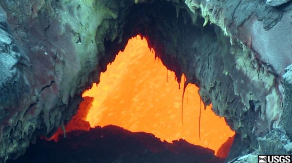
Left: The surface flows active at
the front of the June 27 lava flow are fed from lava flowing
through a lava tube. This collapse of a portion of the roof
has produced a skylight, and a direct view of the fluid lava
stream several meters (yards) beneath the surface. Right:
A remarkable perched lava pond was active on the June 27
lava flow more than a month ago. On August 12 a small lava
flow erupted from the rim of the inactive pond, with the
flow presumably originating from fluid lava that remained in
the perched pond interior. This type of flow is commonly
erupted from perched lava ponds and small lava shields, and
we informally refer to these as "seeps". The seeps have a
characteristic spiny, toothpaste-like, flow texture. Today,
this seep was inactive, but the flow interior remained
incandescent. The front of this small flow can be seen at
the top of the photograph.

Another skylight and view into the tube
supplying lava to the front of the June 27 lava flow.
August 12, 2014 — Kīlauea
June 27 flow continues advancing through forest northeast of Puʻu ʻŌʻō

The June 27 flow remains active, and has
advanced further into the forest over the past week. The
flow front today was 8.5 km (5.3 miles) northeast of the
vent on Puʻu ʻŌʻō (see "map" link above for current flow
field map). The flow's continued brisk advance rate is
likely related, in part, to its continued confinement by
local topography. Today, the narrow flow front was within
one of the many linear depressions (grabens) on the East
Rift Zone. Puʻu ʻŌʻō can be seen in the distance.


Left: Another view of the flow
front, looking east. The small bump on the horizon, near the
center of the photograph, is the forested cone of
Heiheiahulu. Right: Portions of the June 27 lava flow
continue to expand and cover older flows from Puʻu ʻŌʻō.


Left: Thick fume continues to
obscure views into Puʻu ʻŌʻō Crater with the naked eye. The
thermal camera has proven useful recently to see the hidden
activity, which includes several small lava ponds (see
thermal image from the July 29 overflight, below). Right:
A skylight reveals the fluid lava stream within the main
tube on the June 27 lava flow. The recently active perched
lava pond is in the upper left portion of the photograph.

A closer look into the skylight on the
June 27 lava flow, revealing complex structure within the
lava tube. The bright incandescent area is the fluid lava
stream, which was slowly but steadily flowing through the
tube.
August 10, 2014 — Kīlauea
Lava lake activity continues in Halemaʻumaʻu Crater

The usual lava lake activity continues in
Halemaʻumaʻu Crater with no major changes related to the
recent hurricane. This afternoon the lake surface was about
40 meters (130 ft) below the floor of Halemaʻumaʻu Crater,
which has been typical over the past several weeks. Lake
surface migration was from north to south (top of photo to
bottom), and occasional gas bubbles were bursting through
the crust.
August 6, 2014 — Kīlauea
June 27 lava flow reaches forest boundary

The June 27 flow continues to advance at
a brisk rate, and has reached the forest boundary over the
past week. On today's overflight, thick plumes of smoke from
burning vegetation partially obscured the flow front. See
the "maps" link above for today's flow field map.

A wider view of the flow front, looking
east. The June 27 flow is the lighter-colored lava passing
through the center of the photograph.
July 29, 2014 — Kīlauea
June 27 lava flow advance rate increases

The June 27 flow front has advanced more
rapidly over the past four days, and is now 4.2 km (2.6
miles) from the vent. This recent increased advance rate is
due to the confinement of the flow against the slopes of an
older perched lava channel, from 2007. The advance rate will
likely drop in the coming days as the flow passes the
confines of the perched channel and spreads out on flatter
topography.


Left: Another view of the front of
the June 27 flow, looking northeast. The flow front has
narrowed as it has been confined against the slopes of the
2007 perched lava channel, and this is associated with a
higher advance rate of the flow front over the past four
days. Right: View, looking southwest, of Puʻu ʻŌʻō
and the new perched lava pond. Puʻu ʻŌʻō is the fume-filled
crater in the top half of the image. The circular feature in
the lower portion of the photograph is the perched lava pond
active earlier this month, which was fed by the June 27 lava
flow. This perched lava pond is now inactive, but the June
27 flows continue to advance towards the northeast (see
other photos from today).

Visual-thermal comparison of Puʻu ʻŌʻō
crater, looking west. In the normal photograph on the left,
large portions of the crater floor are obscured by thick
volcanic fume. The thermal image on the right can "see"
through this fume, revealing features in the crater. Over
the past month, a large portion of the crater floor has
subsided. Within this triangular subsidence area, three
small lava ponds were active today. Two are visible in this
thermal image, while a third (near the South lava pond) is
blocked by a steep wall from this angle.
July 28, 2014 — Kīlauea
Puʻu ʻŌʻō crater at dawn

A time-lapse camera on the rim of Puʻu ʻŌʻō
crater captured this image at dawn. The view is towards the
southeast, and shows two glowing pits in the southern
portion of the crater floor. Our overflight the next day
showed that these pits are filled with small lava ponds.